Forest and Fire
Management Results
BIOMASS ESTIMATE OF EUCALYPTUS PLANTATIONS
This line of action counted with the intervention of Tesselo and ForestWISE.
This innovative approach for estimate biomass in forests was developed based on satellite images and artificial intelligence models. This methodology was tested in Eucalyptus plantations in national territory.
The creation of this model makes it possible to estimate the biomass of a Eucalyptus tree based on its age, in order to measure its productivity.
At this stage, the results presented were divided into 3 models:
– the tree age model.
– the tree density model
– the age biomass regression model
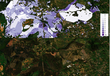
Example of the tree age estimate map.
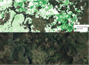
Example of the biomass estimation map.
TREE AGE ESTIMATE
For this model, the age of a plantation was defined as the time that has passed since the last detectable event in the plantation, be it a felling, fire, or planting. Based on this definition, a model was created that can detect these events and estimate the age of the trees.
Validation of the accuracy of this model was done by comparing the validation data and the model prediction for that same validation data.
The average absolute error of the forecast with this method is 4.8 months, calculated over the cut-off and fire dates.
COMBINED BIOMASS MODEL
The combination of the models was done at the pixel level, based on the model that estimates the biomass in Eucalyptus trees as a function of tree age, the age of the Eucalyptus plantations and the model that identifies the density of the plantations (number of trees in each pixel). The combination of these three models can be used to produce a biomass estimate for each pixel of Eucalyptus. The new methodology was tested for all Eucalyptus plantations in continental territory.
TREE DENSITY MODEL
This is a model that estimates the density of eucalyptus plantations as the number of trees per area. This model can be used to count the trees in each pixel. The model was developed in order to be able to monitor several forest areas with time series of Sentinel-2 images.
Validation of model accuracy was done by comparing the validation data and the model prediction for that same validation data.
To have access to the technical reports and associated geographic information you must fill out the following form:
>>>Click Here