This line of action counted with the intervention of Tesselo and ForestWISE.
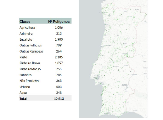
Tesselo developed the second version of the land cover map for the entire national territory, updated to July 2022, thus adding 2 more years of information. In this phase 10,913 polygons were obtained covering 12 classes of study object, in several geographical areas of the country. 85% of the polygons were used for the model to identify the different species. The remaining 15% were used to gauge the accuracy of the model. During this version of the model, it was possible to classify the entire territory into 12 different classes, of which 7 are forest and 5 are non-forest.
This new model is different from the previous model: – Higher model accuracy; – Different methodology for Agroforestry Systems (SAF); – More updated data.
With these new advances in forest knowledge, better forest management will be possible.
To have access to the technical reports and associated geographic information you must fill out the following form: