This line of action counted with the intervention of Tesselo and ForestWISE.
VEGETATION HEIGHT MODEL
A model was developed, based on DeepForest that was trained on canopy data from Florida, USA, for the estimation of vegetation height in the context of the national territory. The vegetation height data were transformed into maps for four study areas containing electrical infrastructures selected under rePLANT.
The results of this super-resolution model for vegetation height detection based on Sentinel-2 data has a high level of detail that can be used to monitor infrastructure based on open medium-resolution data.
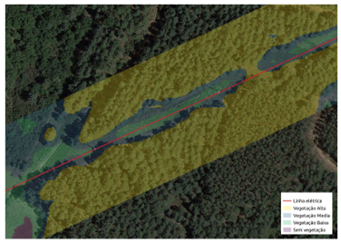
Detail of the vegetation height map showing risk categories
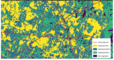
Example of a vegetation height map
The developed model represents an alternative to models that rely on more detailed data sources that have a high cost and lower update frequency. We thus pave the way for the development of a continuous monitoring service, which can cover large areas and complete power grids with a high frequency, and low-cost.
To have access to the technical reports and associated geographic information you must fill out the following form: