Risk management results
Fire propagation simulator
To provide greater protection, prediction and anticipation of the impact of rural fires, both on the forest assets managed by many companies in this sector and on the energy transport
The development of an innovative system that brings a new perspective on integrated forest and fire management, based on scientific and technological knowledge, was the reason for this.
This system provides real-time images, georeferencing the ignition point (smoke column, hot spot) and meteorological information of the location and information about the vegetation, through the placement of sensors, which communicate with the information and simulator systems created for this purpose.
IMFire, developed by the University of Coimbra, is an advanced fire simulation tool supported by state-of-the-art machine learning algorithms and support systems for affected infrastructures.
This simulator allows the determination of fire propagation, based on local wind, fire, fuel and topography conditions.
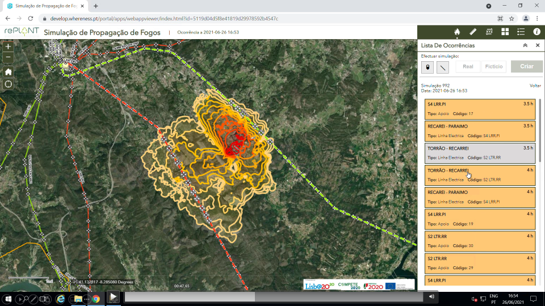
The fire spread simulation service developed by whereness is based on a geographic information system (GIS), which represents the initial location of the fire and the
simulation results, obtained in less than 3 minutes, allow to predict the future location of the fire front up to 5 hours. With a geographic intersection, it is possible to anticipate whether
any electrical, gas, or other infrastructure georeferenced in the system is at risk of being hit by the fire.
In these models two components necessary for simulation are addressed: the behavior of the fire and the forecast of the wind field. Potential data sources where those that are used as input for the models can be collected are also referenced. There are numerical models that can simulate some of the characteristics of fire propagation, such as its propagation speed, intensity, flame length, or others. These models depend on the quantitative description of the factors that affect the actual spread of a fire, such as topography (especially slope), vegetation (forest fuel), and meteorology (especially wind speed and direction). Any simulation of a natural phenomenon is closer to reality the more homogeneous and simpler the surrounding conditions are.